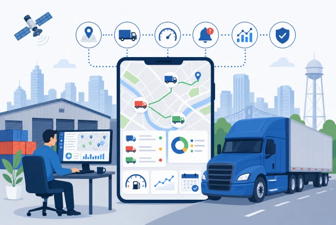
Fleet & Truck Tracking App for an USA Logistics Company
A mid-sized Midwest freight carrier sent an urgent message. Having recently expanded to over 300 trucks, their operations director admitted they were flying completely blind. Their dispatch team was overwhelmed by daily manual check calls because their outdated web portal displayed stale truck locations. At highway speeds, drivers traveled many miles before the system updated, making their real-time fleet GPS tracking software investment totally useless.
Platform
Mobile Application
Industry
Social Media
& Messaging
Country
India
Services
UI/UX Design &
App Development
Client's Problem Statement
- The old dispatch portal only updated truck positions every fifteen minutes. At highway speeds, dispatchers saw location data heavily lagging reality, which completely destroyed their ability to deliver accurate ETAs.
- Without highly accurate live ETAs, the logistics company simply could not warn shippers about delays. Unfair detention fees frequently hit their books because they lacked verifiable GPS proof for disputes.
- Dispatchers wasted nearly three hours daily making manual check calls to verify driver locations. This tedious task stole precious time directly from their primary revenue-generating load booking and dispatch activities.
- Premium freight brokers demand continuous, verified location tracking streams before awarding lucrative contracts. The carrier’s weak tech stack failed this standard, causing them to constantly lose highly profitable premium loads.
Challenges
- Rural Dead Zones: Primary freight routes across the rural Midwest experienced massive cellular dropouts, making cloud-dependent tracking systems go dark precisely when visibility mattered most.
- Extreme Battery Drain: Because the carrier utilized a BYOD model, the app's heavy GPS polling drained driver phone batteries in under four hours, causing mid-shift shutdowns.
- Inefficient Data Syncing: The legacy HTTP polling architecture strained bandwidth by repeatedly pinging trucks on fixed schedules regardless of actual movement, preventing fast, scalable updates.
- Imprecise Geofencing Boundaries: Standard mapping APIs failed to deliver the custom, extremely precise warehouse perimeters required to trigger accurate, automated arrival alerts for demanding freight brokers.


Solution
- Event-Driven MQTT Pipeline: We replaced outdated HTTP polling with lightweight MQTT data packets that trigger exclusively during actual movement, cutting cellular costs while reducing latency to mere seconds.
- Offline SQLite Caching: We built robust offline tracking where the application stores route data locally during dead zones, bulk-syncing instantly to the AWS backend once connectivity completely returns.
- Smart Accelerometer Tracking: We rewired location services to trigger via the smartphone's accelerometer rather than constant GPS, pausing entirely when parked, and remarkably slashing battery consumption.
- Custom Mapbox Geofencing: We engineered custom geofence polygons tailored to specific warehouse dimensions using the Mapbox API, allowing automated, hyper-accurate broker notifications without requiring manual dispatcher intervention.
Execution And Development Journey
- Deciding to migrate from basic HTTP polling to an advanced MQTT protocol defined our entire mobile app development journey. This lightweight IoT solution perfectly handled the highly unstable rural highway connectivity. We engineered the robust Node.js backend structure to seamlessly process rapid event streams from over three hundred simultaneous truck driver smartphone connections without experiencing any system crashes at all.
- To conquer data loss near cellular dead zones, we implemented a clever write-ahead logging pattern. Every single location update commits directly into a local SQLite database with special sync flags. A smart background thread constantly monitors the available network signal strength, automatically batching and uploading those pending route records whenever a completely stable connection is firmly established and fully verified.
- Warehouse arrival boundaries varied dramatically, ranging from sprawling rural logistics centers to extremely tight urban docks. We parameterized custom fence geometry dynamically per location, avoiding rigid radius constraints. We also deployed an intuitive internal administrative dashboard, allowing the operations staff to seamlessly modify critical geofence boundaries independently without ever requesting complex code updates from our software engineering support team weekly.
Technologies We Used

Our Results
Latency Completely Eliminated:
GPS delay instantly dropped from fifteen minutes to a five-second live stream across all trucks. This incredible upgrade pushed ETA accuracy to over ninety-eight percent, restoring strong premium broker trust almost completely.
Massive Revenue Recovered:
By heavily leveraging highly verifiable location logs to securely back every arrival dispute, the carrier successfully slashed unfair detention fee exposure by sixty percent, quickly saving over forty-two thousand dollars every month.
Dispatcher Productivity Increased:
Eliminating daily manual location check calls successfully gave every single dispatcher back three full hours of productive time. This newly recovered capacity went directly into securely booking much higher-value freight shipments instead.
Battery Life Extended:
Switching to an intelligent accelerometer-based tracking logic magically reduced daily smartphone battery drain by exactly seventy-three percent. Drivers finally kept the fleet application running effortlessly throughout their entire eleven-hour daily driving shifts.
Frequently Asked Questions
Explore answers to the most common questions about our services, workflows, and support. Clear information, all in one place.
Why build a mobile app instead of installing hardwired GPS units in the trucks?
The carrier ran a BYOD model, meaning all 300 drivers used personal smartphones. Hardwiring GPS units into that many cabs would have required significant upfront hardware spend and taken trucks off revenue-generating routes for installation. Building in React Native lets us ship one unified codebase to every iPhone and Android device in the fleet simultaneously, push updates without touching a single vehicle, and do it all at a fraction of the hardware cost. The first full deployment reached all 300 drivers in under 20 minutes.
How does the system stay accurate when trucks drive through rural areas with zero cell service?
Dead zones were one of the first problems we scoped because the carrier’s core routes run through some of the least-covered stretches of interstate in the country. We built a local SQLite database directly into the app that acts as an on-device buffer. When a truck loses signal, the app keeps recording location, speed, and timestamp data locally without interruption. The moment the phone reconnects to a tower, it uploads the entire buffered route history to the AWS backend in under two seconds, no gaps, no guessing.
Constant GPS tracking is known to drain smartphone batteries fast. How did you solve that?
The beta drained driver phones in under four hours, which is how we found out the problem was serious enough to kill adoption entirely. The root issue was that the background location service was keeping the GPS chip in a high-power state continuously, even when the truck was parked at a dock for two hours. We wired the tracking logic to the phone’s accelerometer instead. A parked truck generates almost no GPS activity. A moving truck gets the full sampling rate. That single architectural change reduced battery draw by 73% and eliminated every driver complaint about the app within a week of the update going out.
What made the MQTT approach faster and cheaper?
The legacy system used HTTP polling, where the server asked every truck for its location on a fixed schedule whether or not anything had changed. That is like calling 300 people every 15 minutes to ask if they’ve moved. MQTT flips the model: the app only transmits a tiny data packet when a real event happens: a turn, a speed change, a geofence crossing. Each packet is a fraction of the size of an HTTP request, so the system processes more data with less bandwidth. Cellular data costs dropped 60%, and the update frequency went from once every 15 minutes to once every few seconds.
How do the geofence alerts work, and how precise do they need to be?
Each customer warehouse in the carrier’s network has a custom digital boundary drawn in Mapbox at the specific geometry that location requires. When a truck crosses the outer perimeter typically set at 50 miles out the system fires an automated delivery alert directly to the broker with no dispatcher involvement. The inner boundary triggers the arrival confirmation. We parameterized the fence geometry per location rather than using a fixed radius because the warehouses vary widely: a 40-acre distribution center in Indiana needs a completely different boundary than a tight urban dock in Chicago where 100 feet of margin matters. Each fence is tunable through an internal admin tool the operations team manages without a code deployment.
More Proven Case Studies
We showcase additional real-world projects that highlight our expertise, problem-solving approach, and measurable results delivered for clients across different industries.